
Thank you for supporting this site ❤️
Make a donation
Make a donation
Cuito topographic map
Click on the map to display elevation.
Thank you for supporting this site ❤️
Make a donation
Make a donation
Cuito
The town sits on the eastern flank of the Bie Plateau. Due to its elevation, the climate is unusually cool for its tropical location with an average annual temperature is 18 °C. The coolest period is May to August when almost no rain falls. September and October are the hottest months with a little rain. Heavy rain falls in the main rainy season November to April.
Thank you for supporting this site ❤️
Make a donation
Make a donation
About this map
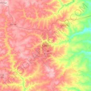
Name: Cuito topographic map, elevation, terrain.
Location: Cuito, Bié Province, Angola (-12.54494 16.77900 -12.22494 17.09900)
Average elevation: 1,673 m
Minimum elevation: 1,518 m
Maximum elevation: 1,789 m
Thank you for supporting this site ❤️
Make a donation
Make a donation
Other topographic maps
Click on a map to view its topography, its elevation and its terrain.