
Thank you for supporting this site ❤️
Make a donation
Make a donation
Le Champ-Saint-Père topographic map
Click on the map to display elevation.
Thank you for supporting this site ❤️
Make a donation
Make a donation
Le Champ-Saint-Père
Le territoire municipal du Champ-Saint-Père s’étend sur 2 475 hectares. L’altitude moyenne de la commune est de 37 mètres, avec des niveaux fluctuant entre 1 et 75 mètres,.
Thank you for supporting this site ❤️
Make a donation
Make a donation
About this map
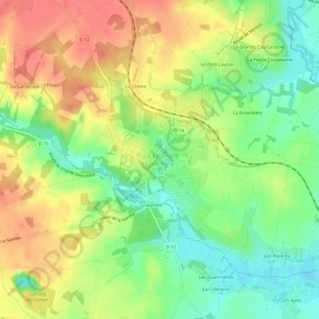
Name: Le Champ-Saint-Père topographic map, elevation, terrain.
Average elevation: 32 m
Minimum elevation: 0 m
Maximum elevation: 65 m
Thank you for supporting this site ❤️
Make a donation
Make a donation