
Thank you for supporting this site ❤️
Make a donation
Make a donation
De Haan topographic map
Click on the map to display elevation.
Thank you for supporting this site ❤️
Make a donation
Make a donation
About this map
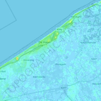
Name: De Haan topographic map, elevation, terrain.
Location: De Haan, Ostend, West Flanders, Flanders, Belgium (51.21967 2.98433 51.31461 3.11530)
Average elevation: 1 m
Minimum elevation: -3 m
Maximum elevation: 23 m
Thank you for supporting this site ❤️
Make a donation
Make a donation
Other topographic maps
Click on a map to view its topography, its elevation and its terrain.