
Thank you for supporting this site ❤️
Make a donation
Make a donation
Chittorgarh topographic map
Click on the map to display elevation.
Thank you for supporting this site ❤️
Make a donation
Make a donation
Chittorgarh
Chittorgarh is located at 24°53′N 74°38′E / 24.88°N 74.63°E / 24.88; 74.63. It has an average elevation of 394 metres (1292 ft).Chittorgarh is located in the southern part of the state of Rajasthan, in the northwestern part of India. It is located beside a high hill near the Gambhiri River. Chittorgarh is located between 23° 32' and 25° 13' north latitudes and between 74° 12' and 75° 49' east longitudes in the southeastern part of Rajasthan state. The district encompasses 350.8 square km (3.17 per cent of the Rajasthan State) area of land.
Thank you for supporting this site ❤️
Make a donation
Make a donation
About this map
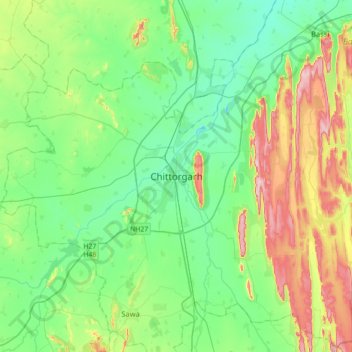
Name: Chittorgarh topographic map, elevation, terrain.
Average elevation: 442 m
Minimum elevation: 371 m
Maximum elevation: 617 m
Thank you for supporting this site ❤️
Make a donation
Make a donation