
Thank you for supporting this site ❤️
Make a donation
Make a donation
Cervino topographic map
Click on the map to display elevation.
Thank you for supporting this site ❤️
Make a donation
Make a donation
About this map
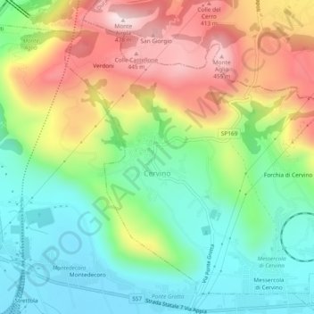
Name: Cervino topographic map, elevation, terrain.
Location: Cervino, Caserta, Campania, Italy (41.02640 14.41031 41.05720 14.45700)
Average elevation: 215 m
Minimum elevation: 45 m
Maximum elevation: 471 m
Thank you for supporting this site ❤️
Make a donation
Make a donation
Other topographic maps
Click on a map to view its topography, its elevation and its terrain.
Thank you for supporting this site ❤️
Make a donation
Make a donation
Thank you for supporting this site ❤️
Make a donation
Make a donation