
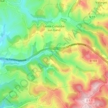
Sainte-Colombe-sur-Gand topographic map
Interactive map
Click on the map to display elevation.
About this map
Name: Sainte-Colombe-sur-Gand topographic map, elevation, terrain.
Average elevation: 592 m
Minimum elevation: 464 m
Maximum elevation: 771 m
Altitude. de 468 m jusqu’à 772 m – À proximité du mont Boussuivre (1 004 m).
Other topographic maps
Click on a map to view its topography, its elevation and its terrain.
Saint-Paul-en-Jarez
France > Auvergne-Rhône-Alpes > Loire
Saint-Paul-en-Jarez, Saint-Étienne, Loire, Auvergne-Rhône-Alpes, France métropolitaine, 42740, France
Average elevation: 494 m
Savigneux
France > Auvergne-Rhône-Alpes > Loire
Savigneux, Montbrison, Loire, Auvergne-Rhône-Alpes, France métropolitaine, 42600, France
Average elevation: 378 m