
Yamango topographic map
Click on the map to display elevation.
About this map
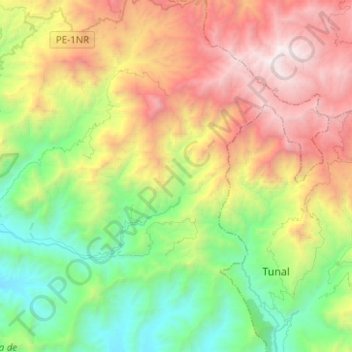
Name: Yamango topographic map, elevation, terrain.
Location: Yamango, Province of Morropón, Piura, Peru (-5.22962 -79.89095 -5.06656 -79.64221)
Average elevation: 1,530 m
Minimum elevation: 195 m
Maximum elevation: 3,658 m
Other topographic maps
Click on a map to view its topography, its elevation and its terrain.