
Make a donation
Shohola Township topographic map
Click on the map to display elevation.
Make a donation
About this map
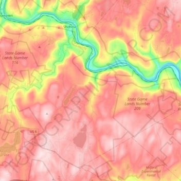
Name: Shohola Township topographic map, elevation, terrain.
Average elevation: 353 m
Minimum elevation: 146 m
Maximum elevation: 463 m
Make a donation
Other topographic maps
Click on a map to view its topography, its elevation and its terrain.
Dingmans Ferry
United States > Pennsylvania > Pike County > Delaware Township
Average elevation: 192 m
Lords Valley
United States > Pennsylvania > Pike County > Blooming Grove Township
Average elevation: 412 m
Make a donation
Make a donation
Lake in the Clouds
United States > Pennsylvania > Pike County > Greene Township
Average elevation: 561 m
Make a donation
Sagamore Estates
United States > Pennsylvania > Pike County > Shohola Township
Average elevation: 412 m
Dingmans Ferry
United States > Pennsylvania > Pike County > Delaware Township
Average elevation: 192 m
Tanglewood Estate
United States > Pennsylvania > Pike County > Palmyra Township
Average elevation: 448 m
Make a donation
Masthope Rapids
United States > Pennsylvania > Pike County > Lackawaxen Township
Average elevation: 313 m
Sagamore Estates
United States > Pennsylvania > Pike County > Shohola Township
Average elevation: 412 m
Pocono Mountain Woodland Lakes
United States > Pennsylvania > Pike County > Dingman Township
Average elevation: 369 m
Make a donation
Lords Valley
United States > Pennsylvania > Pike County > Blooming Grove Township
Average elevation: 412 m
Make a donation
Saw Creek
United States > Pennsylvania > Pike County > Lehman Township > Saw Creek
Average elevation: 276 m
Make a donation