
Thank you for supporting this site ❤️
Make a donation
Make a donation
St. John's topographic map
Click on the map to display elevation.
Thank you for supporting this site ❤️
Make a donation
Make a donation
About this map
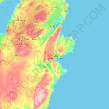
Name: St. John's topographic map, elevation, terrain.
Location: St. John's, Newfoundland, Newfoundland and Labrador, Canada (47.32737 -53.03786 47.63385 -52.61277)
Average elevation: 75 m
Minimum elevation: -1 m
Maximum elevation: 276 m
Thank you for supporting this site ❤️
Make a donation
Make a donation
Other topographic maps
Click on a map to view its topography, its elevation and its terrain.