
Stafford topographic map
Interactive map
Click on the map to display elevation.
About this map
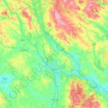
Name: Stafford topographic map, elevation, terrain.
Location: Stafford, Staffordshire, England, United Kingdom (52.71503 -2.41635 52.98056 -1.93333)
Average elevation: 127 m
Minimum elevation: 63 m
Maximum elevation: 256 m
Other topographic maps
Click on a map to view its topography, its elevation and its terrain.
Codsall
United Kingdom > England > Staffordshire > South Staffordshire
Codsall, South Staffordshire, Staffordshire, England, United Kingdom
Average elevation: 124 m
Kingsley Holt
United Kingdom > England > Staffordshire > Staffordshire Moorlands
Kingsley Holt, Staffordshire Moorlands, Staffordshire, England, ST10 2BG, United Kingdom
Average elevation: 184 m
Gratwich
United Kingdom > England > Staffordshire > East Staffordshire > Kingstone
Gratwich, Kingstone, East Staffordshire, Staffordshire, England, ST14 8WE, United Kingdom
Average elevation: 143 m
Grove Hill
United Kingdom > England > Staffordshire > Lichfield
Grove Hill, Lichfield, Staffordshire, England, WS9 9HJ, United Kingdom
Average elevation: 142 m
Burton-on-Trent
United Kingdom > England > Staffordshire > East Staffordshire
Burton-on-Trent, East Staffordshire, Staffordshire, England, DE14 1JN, United Kingdom
Average elevation: 69 m
Newcastle-under-Lyme
United Kingdom > England > Staffordshire
Newcastle-under-Lyme, Staffordshire, England, United Kingdom
Average elevation: 149 m
Alton
United Kingdom > England > Staffordshire > Staffordshire Moorlands
Alton, Staffordshire Moorlands, Staffordshire, England, United Kingdom
Average elevation: 156 m
Farley
United Kingdom > England > Staffordshire > Staffordshire Moorlands
Farley, Staffordshire Moorlands, Staffordshire, England, United Kingdom
Average elevation: 221 m
Cheadle
United Kingdom > England > Staffordshire > Staffordshire Moorlands
Cheadle, Staffordshire Moorlands, Staffordshire, England, United Kingdom
Average elevation: 191 m
Drayton Bassett
United Kingdom > England > Staffordshire > Lichfield > Drayton Basset
Drayton Bassett, Drayton Basset, Lichfield, Staffordshire, England, United Kingdom
Average elevation: 83 m
Boundary
United Kingdom > England > Staffordshire > Staffordshire Moorlands > Boundary
Boundary, Staffordshire Moorlands, Staffordshire, England, ST10 2NU, United Kingdom
Average elevation: 192 m
Leyfields
United Kingdom > England > Staffordshire > Tamworth > Leyfields
Leyfields, Tamworth, Staffordshire, England, B79 8HS, United Kingdom
Average elevation: 66 m
Peak District National Park
United Kingdom > England > Staffordshire
Peak District National Park, Staffordshire, West Midlands, England, United Kingdom
Average elevation: 225 m
Alrewas
United Kingdom > England > Staffordshire > Lichfield > Alrewas
Alrewas, Lichfield, Staffordshire, West Midlands, England, United Kingdom
Average elevation: 59 m
Swan Bank
United Kingdom > England > Staffordshire > Newcastle-under-Lyme > Madeley > Swan Bank
Swan Bank, Madeley, Newcastle-under-Lyme, Staffordshire, West Midlands, England, CW3 9LE, United Kingdom
Average elevation: 135 m
Thorncliffe
United Kingdom > England > Staffordshire > Staffordshire Moorlands > Thorncliffe
Thorncliffe, Staffordshire Moorlands, Staffordshire, West Midlands, England, ST13 7LP, United Kingdom
Average elevation: 312 m
Cheddleton
United Kingdom > England > Staffordshire > Staffordshire Moorlands
Cheddleton, Staffordshire Moorlands, Staffordshire, West Midlands, England, United Kingdom
Average elevation: 204 m
Fradswell
United Kingdom > England > Staffordshire > Stafford > Fradswell
Fradswell, Stafford, Staffordshire, West Midlands, England, United Kingdom
Average elevation: 143 m
Lichfield
United Kingdom > England > Staffordshire > Lichfield
Lichfield, Staffordshire, England, United Kingdom
Average elevation: 91 m
Staffordshire
United Kingdom > England > Staffordshire
Staffordshire, West Midlands, England, United Kingdom
Average elevation: 130 m