
Bukoba topographic map
Interactive map
Click on the map to display elevation.
About this map
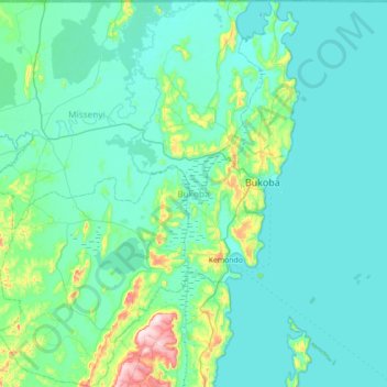
Name: Bukoba topographic map, elevation, terrain.
Location: Bukoba, Kagera, Lake Zone, KASSAMBYA, Tanzania (-1.95244 30.74708 -0.98548 31.88039)
Average elevation: 1,258 m
Minimum elevation: 1,129 m
Maximum elevation: 1,836 m
Other topographic maps
Click on a map to view its topography, its elevation and its terrain.