
Thank you for supporting this site ❤️
Make a donation
Make a donation
Beaune-la-Rolande topographic map
Click on the map to display elevation.
Thank you for supporting this site ❤️
Make a donation
Make a donation
About this map
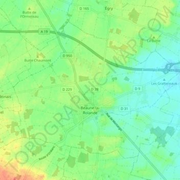
Name: Beaune-la-Rolande topographic map, elevation, terrain.
Average elevation: 107 m
Minimum elevation: 90 m
Maximum elevation: 137 m
Thank you for supporting this site ❤️
Make a donation
Make a donation
Other topographic maps
Click on a map to view its topography, its elevation and its terrain.
Thank you for supporting this site ❤️
Make a donation
Make a donation
Terres du Gd Sous Les Vign
France > Centre-Val de Loire > Loiret > Dordives > Le Grand-sous-les-Vignes
Average elevation: 93 m
Thank you for supporting this site ❤️
Make a donation
Make a donation
La Porte, Château
France > Centre-Val de Loire > Loiret > Autruy-sur-Juine > La Porte
Average elevation: 121 m
Thank you for supporting this site ❤️
Make a donation
Make a donation