
Make a donation
North Twin Peak topographic map
Click on the map to display elevation.
Make a donation
About this map
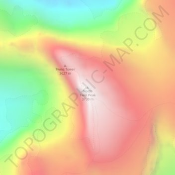
Name: North Twin Peak topographic map, elevation, terrain.
Average elevation: 2,996 m
Minimum elevation: 2,140 m
Maximum elevation: 3,672 m
Make a donation
Other topographic maps
Click on a map to view its topography, its elevation and its terrain.
Maligne Lake
Canada > Alberta > Improvement District No. 12
Wildlife is surprisingly abundant along this high altitude oligotrophic lake. Grizzly bear, black bear, mule deer, caribou, wolves, moose, and mountain sheep are some of the larger mammals that frequent the lake area during the summer season. Bald eagles, golden eagles and osprey also frequent the area and…
Average elevation: 2,125 m
Make a donation
Lawrence Glacier
Canada > Alberta > Improvement District No. 12 > Area A (Kicking Horse/Kinbasket Lake)
Average elevation: 2,619 m
Maligne Lake
Canada > Alberta > Improvement District No. 12
Wildlife is surprisingly abundant along this high altitude oligotrophic lake. Grizzly bear, black bear, mule deer, caribou, wolves, moose, and mountain sheep are some of the larger mammals that frequent the lake area during the summer season. Bald eagles, golden eagles and osprey also frequent the area and…
Average elevation: 2,125 m
Make a donation