
Enns topographic map
Interactive map
Click on the map to display elevation.
About this map
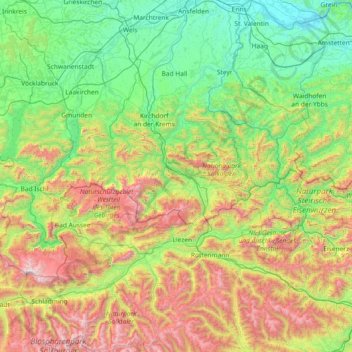
Name: Enns topographic map, elevation, terrain.
Location: Enns, Salzbourg, 5542.0, Autriche (47.24833 13.36447 48.23769 14.76046)
Average elevation: 932 m
Minimum elevation: 224 m
Maximum elevation: 2,841 m
Other topographic maps
Click on a map to view its topography, its elevation and its terrain.
Saalbach-Hinterglemm
Autriche > Salzbourg > Bezirk Zell am See
Saalbach-Hinterglemm, Bezirk Zell am See, Salzbourg, Autriche
Average elevation: 1,517 m
Zell am See
Autriche > Salzbourg > Zell am See
Zell am See, Bezirk Zell am See, Salzbourg, 5700, Autriche
Average elevation: 1,094 m
Hof bei Salzburg
Autriche > Salzbourg > Hof bei Salzburg
Hof bei Salzburg, Salzburg-Umgebung, Salzbourg, 5322, Autriche
Average elevation: 728 m
Wolfgangsee
Autriche > Salzbourg > Sankt Gilgen
Wolfgangsee, Schwand, Sankt Gilgen, Salzburg-Umgebung, Salzbourg, 5340, Autriche
Average elevation: 843 m
Saalfelden am Steinernen Meer
Autriche > Salzbourg > Saalfelden am Steinernen Meer
Saalfelden am Steinernen Meer, Zell am See, Salzbourg, 5760, Autriche
Average elevation: 1,266 m