
Thank you for supporting this site ❤️
Make a donation
Make a donation
Borki topographic map
Click on the map to display elevation.
Thank you for supporting this site ❤️
Make a donation
Make a donation
About this map
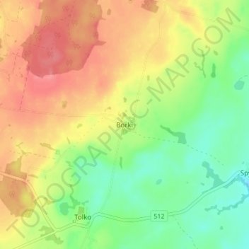
Name: Borki topographic map, elevation, terrain.
Average elevation: 91 m
Minimum elevation: 58 m
Maximum elevation: 124 m
Thank you for supporting this site ❤️
Make a donation
Make a donation
Other topographic maps
Click on a map to view its topography, its elevation and its terrain.
Bartoszyce
Poland > Warmian-Masurian Voivodeship > Bartoszyce County > Bartoszyce
Bartoszyce lies on the left shore of river Łyna River in a valley, approximately 90 kilometres (56 miles) east of Elbląg and 55 kilometres (34 miles) south of Kaliningrad, at an altitude of 3 metres (9.8 feet) above sea level.
Average elevation: 56 m