
Thank you for supporting this site ❤️
Make a donation
Make a donation
Big Flat topographic map
Click on the map to display elevation.
Thank you for supporting this site ❤️
Make a donation
Make a donation
About this map
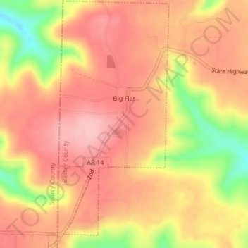
Name: Big Flat topographic map, elevation, terrain.
Location: Big Flat, Baxter County, Arkansas, 72617, United States (35.98889 -92.41512 36.01575 -92.39888)
Average elevation: 354 m
Minimum elevation: 255 m
Maximum elevation: 403 m
Thank you for supporting this site ❤️
Make a donation
Make a donation
Other topographic maps
Click on a map to view its topography, its elevation and its terrain.