
Thank you for supporting this site ❤️
Make a donation
Make a donation
Chapon-Seraing topographic map
Click on the map to display elevation.
Thank you for supporting this site ❤️
Make a donation
Make a donation
About this map
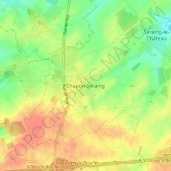
Name: Chapon-Seraing topographic map, elevation, terrain.
Location: Chapon-Seraing, Verlaine, Huy, Liège, Wallonie, 4537, Belgique (50.58967 5.25345 50.62967 5.29345)
Average elevation: 180 m
Minimum elevation: 157 m
Maximum elevation: 200 m
Thank you for supporting this site ❤️
Make a donation
Make a donation
Other topographic maps
Click on a map to view its topography, its elevation and its terrain.
Thank you for supporting this site ❤️
Make a donation
Make a donation