
Thank you for supporting this site ❤️
Make a donation
Make a donation
Estaires topographic map
Click on the map to display elevation.
Thank you for supporting this site ❤️
Make a donation
Make a donation
Estaires
Estaires is located in French Flanders, in the Lys valley at an altitude of 16 m. The Meteren Becque flows into the Lys at this point. It stands 30 km west of Lille, 17 km from Hazebrouck and 14 km from Armentieres. It is twinned with Wielun in Poland.
Thank you for supporting this site ❤️
Make a donation
Make a donation
About this map
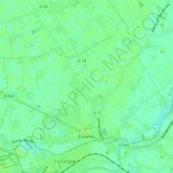
Name: Estaires topographic map, elevation, terrain.
Average elevation: 17 m
Minimum elevation: 12 m
Maximum elevation: 21 m
Thank you for supporting this site ❤️
Make a donation
Make a donation
Other topographic maps
Click on a map to view its topography, its elevation and its terrain.
Thank you for supporting this site ❤️
Make a donation
Make a donation
Thank you for supporting this site ❤️
Make a donation
Make a donation
Thank you for supporting this site ❤️
Make a donation
Make a donation