
Make a donation
Courtney Lake topographic map
Click on the map to display elevation.
Make a donation
About this map
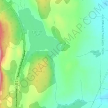
Name: Courtney Lake topographic map, elevation, terrain.
Average elevation: 1,028 m
Minimum elevation: 961 m
Maximum elevation: 1,164 m
Make a donation
Other topographic maps
Click on a map to view its topography, its elevation and its terrain.
Kingsvale
Canada > British Columbia > Thompson-Nicola Regional District > Area N (Beautiful Nicola Valley - South)
Average elevation: 928 m
Lundbom Lake
Canada > British Columbia > Thompson-Nicola Regional District > Area N (Beautiful Nicola Valley - South)
Average elevation: 1,158 m
Kentucky-Alleyne Provincial Park
Canada > British Columbia > Thompson-Nicola Regional District > Area N (Beautiful Nicola Valley - South)
Average elevation: 1,095 m
Brookmere
Canada > British Columbia > Thompson-Nicola Regional District > Area N (Beautiful Nicola Valley - South)
Average elevation: 1,152 m
Make a donation
Aspen Grove
Canada > British Columbia > Thompson-Nicola Regional District > Area N (Beautiful Nicola Valley - South)
Average elevation: 1,165 m