
Thank you for supporting this site ❤️
Make a donation
Make a donation
Les Bruyères topographic map
Click on the map to display elevation.
Thank you for supporting this site ❤️
Make a donation
Make a donation
About this map
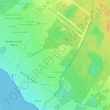
Name: Les Bruyères topographic map, elevation, terrain.
Average elevation: 12 m
Minimum elevation: 0 m
Maximum elevation: 26 m
Thank you for supporting this site ❤️
Make a donation
Make a donation
Other topographic maps
Click on a map to view its topography, its elevation and its terrain.
33510
France > Nouvelle-Aquitaine > Gironde > Andernos-les-Bains > Clos des Fauvettes
Average elevation: 11 m