
Ostrau topographic map
Interactive map
Click on the map to display elevation.
About this map
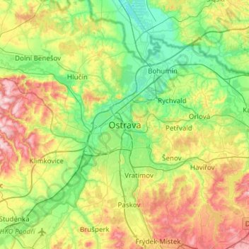
Name: Ostrau topographic map, elevation, terrain.
Average elevation: 258 m
Minimum elevation: 184 m
Maximum elevation: 408 m
Other topographic maps
Click on a map to view its topography, its elevation and its terrain.
Polanka
Tschechien > Mährisch-Schlesien > Mährisch-Schlesische Region > Ostrau > Polanka
Polanka, Ostrau, Bezirk Ostrau-Stadt, Mährisch-Schlesische Region, Mährisch-Schlesien, 72525, Tschechien
Average elevation: 242 m