
Warwick topographic map
Click on the map to display elevation.
Warwick
Warwick experiences the usual English maritime climate, marked by a narrow temperature range, mild winters and cool summers. The nearest official Met Office weather station is at Wellesbourne, about 6 miles (10 km) south of the town centre and at a similar elevation. The absolute maximum temperature (also the absolute maximum for the county of Warwickshire) stands at 36.1 °C (97.0 °F) recorded in August 1990. During a typical year, the warmest day should reach 30.0 °C (86.0 °F), and 16.5 days should report a maximum of 25.1 °C (77.2 °F) or higher. The lowest recorded temperature is −17.8 °C (0.0 °F), recorded in January 1982. Typically, 53.3 air frosts are recorded in an "average" year. Rainfall averages out at 608 millimetres (23.9 in) per year, with over 114 days seeing 1 mm (0.04 in) or more falling. All averages refer to the 1971–2000 period.
About this map
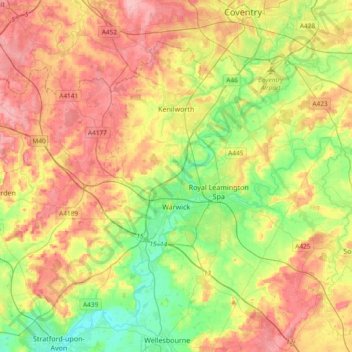
Name: Warwick topographic map, elevation, terrain.
Location: Warwick, Warwickshire, England, United Kingdom (52.21370 -1.78018 52.38928 -1.40608)
Average elevation: 87 m
Minimum elevation: 35 m
Maximum elevation: 145 m
Other topographic maps
Click on a map to view its topography, its elevation and its terrain.