
Thank you for supporting this site ❤️
Make a donation
Make a donation
Taloqan topographic map
Click on the map to display elevation.
Thank you for supporting this site ❤️
Make a donation
Make a donation
Taloqan
Taloqan sits at an altitude of 876 m (2,874 ft) above sea level, and has a land area of 107 km2 (41 sq mi) with 28,691 dwelling units in it. The city is administratively divided into 6 city districts (nahias). There is a major road that passes through the city, linking it with nearby Kunduz in the west and Fayzabad in Badakhshan Province in the northeast.
Thank you for supporting this site ❤️
Make a donation
Make a donation
About this map
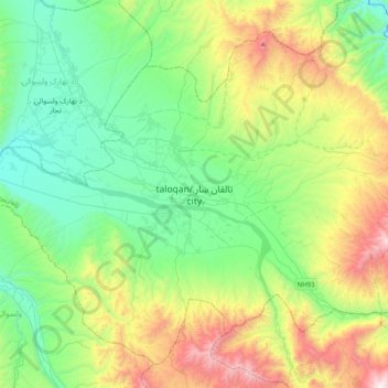
Name: Taloqan topographic map, elevation, terrain.
Location: Taloqan, Taluqan District, Takhar Province, 3751, Afghanistan (36.57455 69.38091 36.89455 69.70091)
Average elevation: 1,069 m
Minimum elevation: 594 m
Maximum elevation: 2,199 m
Thank you for supporting this site ❤️
Make a donation
Make a donation