
Thank you for supporting this site ❤️
Make a donation
Make a donation
Cerro Lo Galindo topographic map
Click on the map to display elevation.
Thank you for supporting this site ❤️
Make a donation
Make a donation
About this map
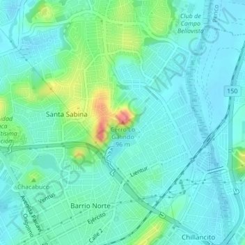
Name: Cerro Lo Galindo topographic map, elevation, terrain.
Average elevation: 24 m
Minimum elevation: 8 m
Maximum elevation: 83 m
Thank you for supporting this site ❤️
Make a donation
Make a donation
Other topographic maps
Click on a map to view its topography, its elevation and its terrain.
Laguna Las Tres Pascualas
Chile > Región del Biobío > Provincia de Concepción > Concepción
Average elevation: 23 m