
Make a donation
Peloponnese topographic map
Click on the map to display elevation.
Make a donation
About this map
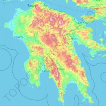
Name: Peloponnese topographic map, elevation, terrain.
Location: Peloponnese, Greece (36.38525 21.10507 38.34141 23.52452)
Average elevation: 257 m
Minimum elevation: -6 m
Maximum elevation: 2,293 m
Make a donation
Other topographic maps
Click on a map to view its topography, its elevation and its terrain.
Ρίζα
Greece > Region of Crete > Lasithi Regional Unit > Ierapetra Municipal Unit
Average elevation: 553 m
Make a donation
Kala Nera
Greece > Thessaly and Central Greece > Regional Unit of Magnesia > Municipla unit of Milies
Average elevation: 84 m
Mitikas
Greece > Peloponnese, Western Greece and the Ionian > Aetolia-Acarnania Regional Unit > Municipal Unit of Alyzia
Average elevation: 27 m
Make a donation
Ρόξας
Greece > Peloponnese, Western Greece and the Ionian > Arcadia Regional Unit > Municipal Unit of Gortyna
Average elevation: 390 m