
Sonnleitn topographic map
Interactive map
Click on the map to display elevation.
About this map
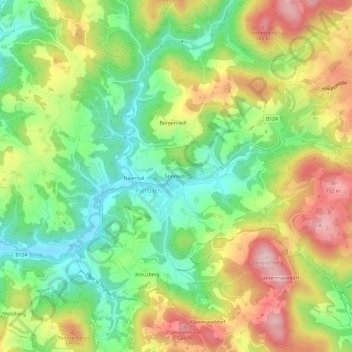
Name: Sonnleitn topographic map, elevation, terrain.
Location: Sonnleitn, Pierbach, Bezirk Freistadt, 4282, Österreich (48.32986 14.74123 48.36986 14.78123)
Average elevation: 596 m
Minimum elevation: 480 m
Maximum elevation: 747 m
Other topographic maps
Click on a map to view its topography, its elevation and its terrain.
Kreuzberg
Österreich > Bezirk Freistadt > Pierbach
Kreuzberg, Pierbach, Bezirk Freistadt, 4282, Österreich
Average elevation: 597 m