
Ślęza topographic map
Interactive map
Click on the map to display elevation.
About this map
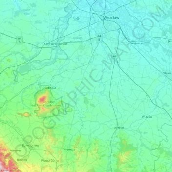
Name: Ślęza topographic map, elevation, terrain.
Location: Ślęza, Landkreis Breslau, Woiwodschaft Niederschlesien, Polen (50.64749 16.75587 51.15965 17.01795)
Average elevation: 183 m
Minimum elevation: 106 m
Maximum elevation: 938 m
Other topographic maps
Click on a map to view its topography, its elevation and its terrain.
Elsbach
Polen > Woiwodschaft Niederschlesien > Landkreis Breslau
Elsbach, Landkreis Breslau, Woiwodschaft Niederschlesien, Polen
Average elevation: 160 m