
Make a donation
Koru Mahallesi topographic map
Click on the map to display elevation.
Make a donation
About this map
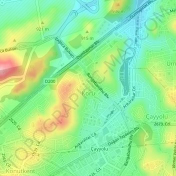
Name: Koru Mahallesi topographic map, elevation, terrain.
Average elevation: 900 m
Minimum elevation: 851 m
Maximum elevation: 987 m
Make a donation
Other topographic maps
Click on a map to view its topography, its elevation and its terrain.
Ankara
Ankara has a cold semi-arid climate (Köppen climate classification: BSk). Under the Trewartha climate classification, Ankara has a temperate humid continental climate (Dc). Due to its elevation and inland location, Ankara has cold and snowy winters, and hot and dry summers. Rainfall occurs mostly during the…
Average elevation: 1,082 m
Make a donation
Ankara
Ankara has a cold semi-arid climate (Köppen climate classification: BSk). Under the Trewartha climate classification, Ankara has a temperate humid continental climate (Dc). Due to its elevation and inland location, Ankara has cold and snowy winters, and hot and dry summers. Rainfall occurs mostly during the…
Average elevation: 1,082 m