
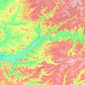
Communauté de communes Fumel Vallée du Lot topographic map
Interactive map
Click on the map to display elevation.
About this map
Name: Communauté de communes Fumel Vallée du Lot topographic map, elevation, terrain.
Average elevation: 172 m
Minimum elevation: 53 m
Maximum elevation: 309 m
Other topographic maps
Click on a map to view its topography, its elevation and its terrain.
Sainte-Livrade-sur-Lot
France > Nouvelle-Aquitaine > Lot-et-Garonne
Sainte-Livrade-sur-Lot, Villeneuve-sur-Lot, Lot-et-Garonne, Nouvelle-Aquitaine, France métropolitaine, 47110, France
Average elevation: 72 m
Haut
France > Nouvelle-Aquitaine > Lot-et-Garonne > Razimet
Haut, Razimet, Nérac, Lot-et-Garonne, Nouvelle-Aquitaine, France métropolitaine, 47160, France
Average elevation: 80 m
La Croix-Blanche
France > Nouvelle-Aquitaine > Lot-et-Garonne
La Croix-Blanche, Agen, Lot-et-Garonne, Nouvelle-Aquitaine, France métropolitaine, 47340, France
Average elevation: 180 m
Cancon
France > Nouvelle-Aquitaine > Lot-et-Garonne
Cancon, Villeneuve-sur-Lot, Lot-et-Garonne, Nouvelle-Aquitaine, France métropolitaine, 47290, France
Average elevation: 132 m
Bruch
France > Nouvelle-Aquitaine > Lot-et-Garonne
Bruch, Nérac, Lot-et-Garonne, Nouvelle-Aquitaine, France métropolitaine, 47130, France
Average elevation: 73 m
Laplume
France > Nouvelle-Aquitaine > Lot-et-Garonne
Laplume, Agen, Lot-et-Garonne, Nouvelle-Aquitaine, France métropolitaine, 47310, France
Average elevation: 137 m
Villeneuve-sur-Lot
France > Nouvelle-Aquitaine > Lot-et-Garonne
Villeneuve-sur-Lot, Lot-et-Garonne, Nouvelle-Aquitaine, France métropolitaine, 47300, France
Average elevation: 99 m
Foulayronnes
France > Nouvelle-Aquitaine > Lot-et-Garonne
Foulayronnes, Agen, Lot-et-Garonne, Nouvelle-Aquitaine, France métropolitaine, 47510, France
Average elevation: 146 m
Layrac
France > Nouvelle-Aquitaine > Lot-et-Garonne
Layrac, Agen, Lot-et-Garonne, Nouvelle-Aquitaine, France métropolitaine, 47390, France
Average elevation: 91 m
Lacapelle-Biron
France > Nouvelle-Aquitaine > Lot-et-Garonne
Lacapelle-Biron, Villeneuve-sur-Lot, Lot-et-Garonne, Nouvelle-Aquitaine, France métropolitaine, 47150, France
Average elevation: 199 m
Latuque
France > Nouvelle-Aquitaine > Lot-et-Garonne > Bon-Encontre > Latuque
Latuque, Bon-Encontre, Agen, Lot-et-Garonne, Nouvelle-Aquitaine, France métropolitaine, 47240, France
Average elevation: 143 m
Le Passage
France > Nouvelle-Aquitaine > Lot-et-Garonne
Le Passage, Agen, Lot-et-Garonne, Nouvelle-Aquitaine, France métropolitaine, 47520, France
Average elevation: 61 m
Libos
France > Nouvelle-Aquitaine > Lot-et-Garonne > Monsempron-Libos > Libos
Libos, Monsempron-Libos, Villeneuve-sur-Lot, Lot-et-Garonne, Nouvelle-Aquitaine, France métropolitaine, 47500, France
Average elevation: 91 m
Marmande
France > Nouvelle-Aquitaine > Lot-et-Garonne
Marmande, Lot-et-Garonne, Nouvelle-Aquitaine, France métropolitaine, 47200, France
Average elevation: 41 m
Meilhan-sur-Garonne
France > Nouvelle-Aquitaine > Lot-et-Garonne
Meilhan-sur-Garonne, Marmande, Lot-et-Garonne, Nouvelle-Aquitaine, France métropolitaine, 47180, France
Average elevation: 42 m
Saint-Martin-Petit
France > Nouvelle-Aquitaine > Lot-et-Garonne > Saint-Martin-Petit
Saint-Martin-Petit, Marmande, Lot-et-Garonne, Nouvelle-Aquitaine, France métropolitaine, 47180, France
Average elevation: 58 m
Virazeil
France > Nouvelle-Aquitaine > Lot-et-Garonne > Virazeil
Virazeil, Marmande, Lot-et-Garonne, Nouvelle-Aquitaine, France métropolitaine, 47200, France
Average elevation: 64 m
Tayrac
France > Nouvelle-Aquitaine > Lot-et-Garonne
Tayrac, Agen, Lot-et-Garonne, Nouvelle-Aquitaine, France métropolitaine, 47270, France
Average elevation: 125 m
Tonneins
France > Nouvelle-Aquitaine > Lot-et-Garonne
Tonneins, Marmande, Lot-et-Garonne, Nouvelle-Aquitaine, France métropolitaine, 47400, France
Average elevation: 49 m
Escassefort
France > Nouvelle-Aquitaine > Lot-et-Garonne
Escassefort, Marmande, Lot-et-Garonne, Nouvelle-Aquitaine, France métropolitaine, 47350, France
Average elevation: 89 m
Prayssas
France > Nouvelle-Aquitaine > Lot-et-Garonne
Prayssas, Agen, Lot-et-Garonne, Nouvelle-Aquitaine, France métropolitaine, 47360, France
Average elevation: 136 m
Guérin
France > Nouvelle-Aquitaine > Lot-et-Garonne
Guérin, Marmande, Lot-et-Garonne, Nouvelle-Aquitaine, France métropolitaine, 47250, France
Average elevation: 110 m