
Thank you for supporting this site ❤️
Make a donation
Make a donation
Gorsedd topographic map
Click on the map to display elevation.
Thank you for supporting this site ❤️
Make a donation
Make a donation
About this map
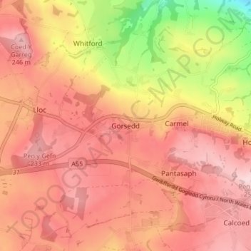
Name: Gorsedd topographic map, elevation, terrain.
Location: Gorsedd, Flintshire, Wales, CH8 8QA, United Kingdom (53.26068 -3.29356 53.30068 -3.25356)
Average elevation: 179 m
Minimum elevation: 28 m
Maximum elevation: 255 m
Thank you for supporting this site ❤️
Make a donation
Make a donation
Other topographic maps
Click on a map to view its topography, its elevation and its terrain.