
Thank you for supporting this site ❤️
Make a donation
Make a donation
Pyle topographic map
Click on the map to display elevation.
Thank you for supporting this site ❤️
Make a donation
Make a donation
About this map
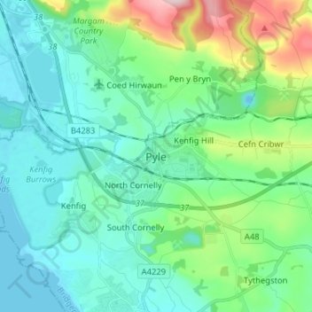
Name: Pyle topographic map, elevation, terrain.
Location: Pyle, Bridgend County Borough, Wales, CF33 6HS, United Kingdom (51.48880 -3.73328 51.56880 -3.65328)
Average elevation: 66 m
Minimum elevation: -7 m
Maximum elevation: 310 m
Thank you for supporting this site ❤️
Make a donation
Make a donation
Other topographic maps
Click on a map to view its topography, its elevation and its terrain.
Thank you for supporting this site ❤️
Make a donation
Make a donation
Thank you for supporting this site ❤️
Make a donation
Make a donation