
Thank you for supporting this site ❤️
Make a donation
Make a donation
Daine II topographic map
Click on the map to display elevation.
Thank you for supporting this site ❤️
Make a donation
Make a donation
About this map
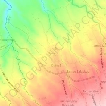
Name: Daine II topographic map, elevation, terrain.
Location: Daine II, Indang, Cavite, Calabarzon, 4122, Philippines (14.17257 120.82388 14.21257 120.86388)
Average elevation: 251 m
Minimum elevation: 135 m
Maximum elevation: 338 m
Thank you for supporting this site ❤️
Make a donation
Make a donation
Other topographic maps
Click on a map to view its topography, its elevation and its terrain.