
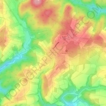
Auderath topographic map
Interactive map
Click on the map to display elevation.
About this map
Name: Auderath topographic map, elevation, terrain.
Average elevation: 441 m
Minimum elevation: 374 m
Maximum elevation: 497 m
Other topographic maps
Click on a map to view its topography, its elevation and its terrain.
Faid
Allemagne > Rhénanie-Palatinat > Landkreis Cochem-Zell
Faid, Cochem, Landkreis Cochem-Zell, Rhénanie-Palatinat, Allemagne
Average elevation: 355 m
Lutzerath
Allemagne > Rhénanie-Palatinat > Landkreis Cochem-Zell
Lutzerath, Ulmen, Landkreis Cochem-Zell, Rhénanie-Palatinat, 56826, Allemagne
Average elevation: 384 m
Cochem
Allemagne > Rhénanie-Palatinat > Landkreis Cochem-Zell
Cochem, Landkreis Cochem-Zell, Rhénanie-Palatinat, Allemagne
Average elevation: 286 m
Zell (Mosel)
Allemagne > Rhénanie-Palatinat > Landkreis Cochem-Zell
Zell (Mosel), Landkreis Cochem-Zell, Rhénanie-Palatinat, 56856, Allemagne
Average elevation: 287 m