
Thank you for supporting this site ❤️
Make a donation
Make a donation
Burgh-Haamstede topographic map
Click on the map to display elevation.
Thank you for supporting this site ❤️
Make a donation
Make a donation
About this map
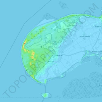
Name: Burgh-Haamstede topographic map, elevation, terrain.
Location: Burgh-Haamstede, Schouwen-Duiveland, Zeeland, Netherlands (51.65032 3.61134 51.75409 3.79466)
Average elevation: 1 m
Minimum elevation: -5 m
Maximum elevation: 36 m
Thank you for supporting this site ❤️
Make a donation
Make a donation
Other topographic maps
Click on a map to view its topography, its elevation and its terrain.