
Thank you for supporting this site ❤️
Make a donation
Make a donation
Monte Fionchi topographic map
Click on the map to display elevation.
Thank you for supporting this site ❤️
Make a donation
Make a donation
About this map
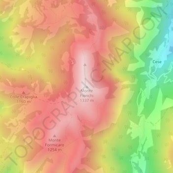
Name: Monte Fionchi topographic map, elevation, terrain.
Location: Monte Fionchi, Spoleto, Perugia, Umbria, 06049, Italia (42.67431 12.77238 42.67441 12.77248)
Average elevation: 1,007 m
Minimum elevation: 530 m
Maximum elevation: 1,331 m
Thank you for supporting this site ❤️
Make a donation
Make a donation
Other topographic maps
Click on a map to view its topography, its elevation and its terrain.