
Make a donation
Mount Washburn topographic map
Click on the map to display elevation.
Make a donation
Mount Washburn
Mount Washburn, elevation 10,219 feet (3,115 m), is a prominent mountain peak in the Washburn Range in Yellowstone National Park, Wyoming. The peak was named in 1870 to honor Henry D. Washburn, leader of the Washburn–Langford–Doane Expedition. The Washburn Range is one of two mountains ranges completely within the boundaries of Yellowstone.
Make a donation
About this map
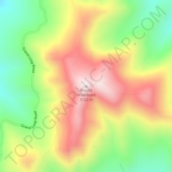
Name: Mount Washburn topographic map, elevation, terrain.
Location: Mount Washburn, Park County, Wyoming, United States (44.79751 -110.43384 44.79761 -110.43374)
Average elevation: 2,798 m
Minimum elevation: 2,503 m
Maximum elevation: 3,109 m
Make a donation
Other topographic maps
Click on a map to view its topography, its elevation and its terrain.
Cody
United States > Wyoming > Park County
Cody's elevation is approximately 5016 ft (1,500 m) above sea level. The main part of the city is split across three levels, separated by about 60 feet (18 m).
Average elevation: 1,557 m
Cody
United States > Wyoming > Park County
Cody's elevation is approximately 5016 ft (1,500 m) above sea level. The main part of the city is split across three levels, separated by about 60 feet (18 m).
Average elevation: 1,557 m
Make a donation
Cody
United States > Wyoming > Park County
Cody's elevation is approximately 4,997 feet (1,523 m) above sea level. The main part of the city is split across three levels, separated by about 60 feet (18 m).
Average elevation: 1,557 m