
Thank you for supporting this site ❤️
Make a donation
Make a donation
Silver Star Mountain topographic map
Click on the map to display elevation.
Thank you for supporting this site ❤️
Make a donation
Make a donation
About this map
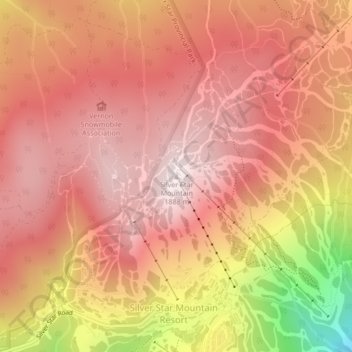
Name: Silver Star Mountain topographic map, elevation, terrain.
Average elevation: 1,706 m
Minimum elevation: 1,286 m
Maximum elevation: 1,886 m
Thank you for supporting this site ❤️
Make a donation
Make a donation
Other topographic maps
Click on a map to view its topography, its elevation and its terrain.
Silver Star Provincial Park
Canada > British Columbia > Regional District of North Okanagan > Area C (Silver Star)
Average elevation: 1,483 m