
Thank you for supporting this site ❤️
Make a donation
Make a donation
Carkeek Park topographic map
Click on the map to display elevation.
Thank you for supporting this site ❤️
Make a donation
Make a donation
About this map
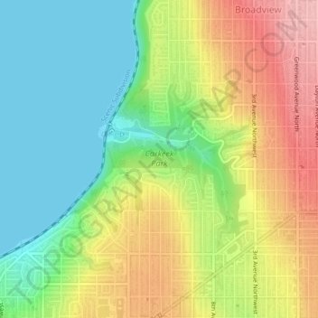
Name: Carkeek Park topographic map, elevation, terrain.
Average elevation: 64 m
Minimum elevation: 0 m
Maximum elevation: 149 m
Thank you for supporting this site ❤️
Make a donation
Make a donation
Other topographic maps
Click on a map to view its topography, its elevation and its terrain.
Thank you for supporting this site ❤️
Make a donation
Make a donation
Thank you for supporting this site ❤️
Make a donation
Make a donation
Thank you for supporting this site ❤️
Make a donation
Make a donation
Arbor Heights
United States > Washington > King County > Seattle > Arbor Heights
Average elevation: 60 m
Thank you for supporting this site ❤️
Make a donation
Make a donation