
Laupheim topographic map
Click on the map to display elevation.
Laupheim
The elevation within the city confines ranges from 509 m (1670 ft) above sea level at the bottom of the valley to 539 m (1768 ft) in the outlying suburban areas.
About this map
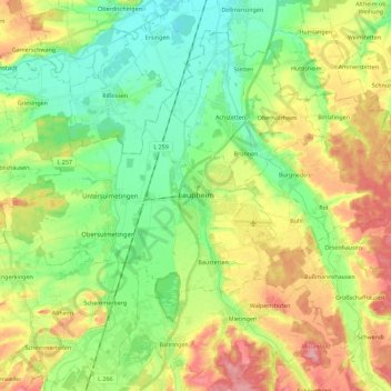
Name: Laupheim topographic map, elevation, terrain.
Average elevation: 523 m
Minimum elevation: 478 m
Maximum elevation: 592 m
Other topographic maps
Click on a map to view its topography, its elevation and its terrain.
Roggensee
Germany > Baden-Württemberg > Landkreis Biberach > Bad Schussenried
Average elevation: 661 m