
Thank you for supporting this site ❤️
Make a donation
Make a donation
Simmershofen topographic map
Click on the map to display elevation.
Thank you for supporting this site ❤️
Make a donation
Make a donation
About this map
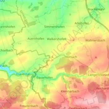
Name: Simmershofen topographic map, elevation, terrain.
Average elevation: 354 m
Minimum elevation: 286 m
Maximum elevation: 425 m
Thank you for supporting this site ❤️
Make a donation
Make a donation
Other topographic maps
Click on a map to view its topography, its elevation and its terrain.
Kirschberg
Duitsland > Beieren > Landkreis Neustadt an der Aisch-Bad Windsheim > Ippesheim
Average elevation: 321 m
Abteiberg
Duitsland > Beieren > Landkreis Neustadt an der Aisch-Bad Windsheim > Markt Taschendorf
Average elevation: 374 m