
Contamana topographic map
Interactive map
Click on the map to display elevation.
Contamana
Die Stadt Contamana liegt auf einer Höhe von 134 m im peruanischen Amazonastiefland am rechten Flussufer des Río Ucayali. Pucallpa, die Hauptstadt der Region Ucayali, liegt 125 km südsüdöstlich von Contamana.
About this map
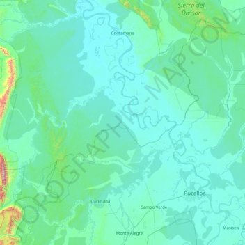
Name: Contamana topographic map, elevation, terrain.
Location: Contamana, Ucayali, Loreto, Peru (-8.71614 -75.98556 -7.13927 -74.49950)
Average elevation: 220 m
Minimum elevation: 117 m
Maximum elevation: 2,179 m