
Make a donation
Los Cristianos topographic map
Click on the map to display elevation.
Make a donation
About this map
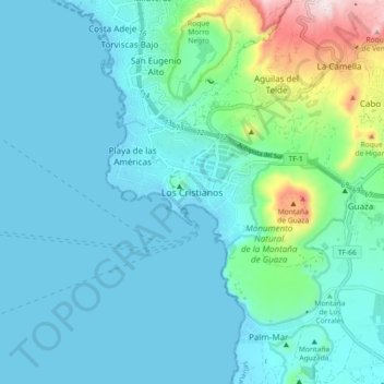
Name: Los Cristianos topographic map, elevation, terrain.
Average elevation: 85 m
Minimum elevation: -2 m
Maximum elevation: 548 m
Make a donation
Other topographic maps
Click on a map to view its topography, its elevation and its terrain.
Gran Canaria
Gran Canaria is located in the Atlantic Ocean in a region known as Macaronesia about 150 kilometres (93 mi) off the northwestern coast of Africa and about 1,350 km (840 mi) from Europe. With an area of 1,560 km2 (602 sq. mi) and an altitude of 1,956 m (6,417 ft) at Morro de la Agujereada, Gran Canaria is the…
Average elevation: 335 m
Tenerife
Teide National Park, located in the center of the island, is also a UNESCO World Heritage Site. It includes Mount Teide, which has the highest elevation in Spain, and the highest among all the islands in the Atlantic Ocean. It is also the third-largest volcano in the world, when measured from its base. Another…
Average elevation: 281 m
Canary Islands
The Canary Islands, especially Tenerife, Gran Canaria, Fuerteventura, and Lanzarote, are a major tourist destination, with over 12 million visitors per year. This is due to their beaches, subtropical climate, and important natural attractions, especially Maspalomas in Gran Canaria, Teide National Park, and…
Average elevation: 16 m
Make a donation
Make a donation
El Rosario
The seat of the municipality, La Esperanza, sits at an elevation of 900 meters above sea level, with historic architecture of whitewashed houses with wooden balconies.
Average elevation: 772 m
San Bartolomé de Tirajana
The municipality contains the large beach resorts of Maspalomas, including Playa del Inglés and San Agustín, and the Pilancones natural park. The municipal capital, the village of San Bartolomé de Tirajana is situated in the mountains, 17 km (11 mi) from the coast and 27 km (17 mi) south-west of Las Palmas,…
Average elevation: 508 m
Make a donation
Parque de la Puerta de Tierra
Spain > Canary Islands > San Juan del Reparo (La Culata) > San Pedro de Daute
Average elevation: 182 m
La Palma
La Palma is characterized by two main climate types: the warm/hot summer Mediterranean climate (Köppen: Csb/Csa), characterized by dry summers and humid winters, is prevalent in the northern coast and in the mid to high altitudes of the island. At lower altitudes, particularly at the south and southwest…
Average elevation: 296 m
Make a donation
Los Llanos de Aridane
The municipality covers an area of 35.79 square kilometres (13.82 sq mi). Its altitude is 325 meters (1,066 ft) above sea level and has a coastal length of 6.43 km (4 mi). Its main neighborhoods are: Los Llanos, Argual, Montaña Tenisca, El Roque, Los Barros, La Laguna, Todoque, Las Manchas de Abajo, Puerto…
Average elevation: 357 m
Make a donation
Make a donation
Tenerife
Teide National Park, located in the center of the island, is also a UNESCO World Heritage Site. It includes Mount Teide, which has the highest elevation in Spain, and the highest elevation among all the islands in the Atlantic Ocean. It is also the third-largest volcano in the world, when measured from its…
Average elevation: 281 m
Make a donation
Make a donation
La Orotava
The town La Orotava, which is the administrative centre of the municipality and also its largest settlement, is situated near the north coast, at about 400 m elevation in the Orotava Valley. It is 4 km southeast of Puerto de la Cruz and 28 km southwest of the island's capital, Santa Cruz de Tenerife. The TF-5…
Average elevation: 1,257 m
Icod de los Vinos
Icod has an area of 95.90 km², is situated at an altitude of 235 metres above sea level, and has a population of 23,092 as of 2013.
Average elevation: 1,035 m
Make a donation
Antigua
Located in the Leeward Islands Antigua has an area of 281 square kilometres (108 sq mi) with 87 kilometres (54 mi) of coastline. The highest elevation on the island is 402 metres (1,319 ft).
Average elevation: 221 m
Santa María de Guía de Gran Canaria
Spain > Canary Islands > Santa María de Guía de Gran Canaria
Average elevation: 488 m
Make a donation