
Make a donation
Caruaru topographic map
Click on the map to display elevation.
Make a donation
Caruaru
The municipality lies within the Borborema Province geo-environmental unit, characterized by high massifs and hills with altitudes ranging from 600 to 1,000 meters. The relief is predominantly rugged, with deep and dissected valleys, and an average elevation of 554 meters above sea level. Located on the Borborema Plateau, its highest point is Monte Bom Jesus, at 630 meters above sea level.
Make a donation
About this map
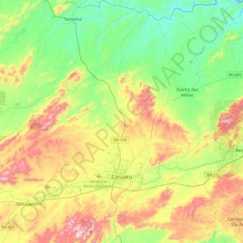
Name: Caruaru topographic map, elevation, terrain.
Average elevation: 535 m
Minimum elevation: 263 m
Maximum elevation: 1,020 m
Make a donation
Other topographic maps
Click on a map to view its topography, its elevation and its terrain.
Praça Farias Neves
Brazil > Pernambuco > Região Metropolitana do Recife > Recife
Average elevation: 22 m
Make a donation
Ana de Alburquerque
Brazil > Pernambuco > Região Metropolitana do Recife > Igarassu
Average elevation: 17 m
Boa Paz
Brazil > Pernambuco > Região Administrativa Integrada de Desenvolvimento do Polo Petrolina e Juazeiro > Petrolina
Average elevation: 379 m
Fernando de Noronha
Fernando de Noronha (Portuguese pronunciation: [feʁˈnɐ̃du dʒi noˈɾoɲɐ]) is an archipelago in the Atlantic Ocean, part of the State of Pernambuco, Brazil, and located 354 km (191 nmi; 220 mi) off the Brazilian coast. It consists of 21 islands and islets, extending over an area of 26 km2 (10 sq mi).…
Average elevation: 4 m
Make a donation
Saint Peter and Saint Paul Archipelago
The Saint Peter and Saint Paul Rocks are situated in the Atlantic Ocean, 100 km (62 mi) north of the Equator, and are the only group of Brazilian oceanic islets in the Northern Hemisphere. The nearest point in the Brazilian coast, is Cabo do Calcanhar, Rio Grande do Norte, approximately 1,010 kilometres (630…
Average elevation: 0 m