
Make a donation
Guaviare topographic map
Click on the map to display elevation.
Make a donation
About this map
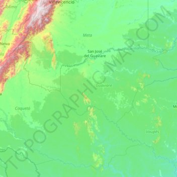
Name: Guaviare topographic map, elevation, terrain.
Location: Guaviare, RAP Amazonía, Colombia (-0.91056 -75.42029 4.28944 -70.22029)
Average elevation: 345 m
Minimum elevation: 83 m
Maximum elevation: 4,079 m
Make a donation
Other topographic maps
Click on a map to view its topography, its elevation and its terrain.
Manizales
Manizales is the capital city of one of the smallest Colombian departments. The city is described as having an "abrupt topography", and lies on the Colombian Central Mountain Range (part of the longest continental mountain range, the Andes), with a great deal of ridgelines and steep slopes, which, combined…
Average elevation: 1,933 m
Make a donation
Magdalena
The Department of Magdalena, because of its terrain, and proximity to the sea has an unstable weather. Its Climate is mainly dictated by its global positioning, and because the department of Magdalena is located on the Intertropical Convergence Zone it possess an inter-tropical climate. Temperature in the…
Average elevation: 407 m
Make a donation
Bucaramanga
Bucaramanga is located on a plateau in the Cordillera Oriental of the Colombian Andes, and many residents occupy unstable lands descending steeply from the meseta. Westbound of it, the Rio de Oro Canyon is located at an altitude of 600 metres (2,000 ft) above sea level. Eastbound, the Andean Range rises up in…
Average elevation: 1,269 m
Quindío
With law 61 of 1985, the Colombian Congress adopted the Quindío wax palm tree, Ceroxylon quindiuense, a local endangered species adapted to high altitudes, as the National Tree. As ratified on September 16, 1985, by the then president of Colombia, Belisario Betancur, the law states: "The species commonly…
Average elevation: 2,057 m
Perimetro Urbano Pereira
Pereira, like many Colombian cities, has high-elevation areas with difficult access or flat or steep parts. The streets are laid out according to the elevation of the respective zones.
Average elevation: 1,486 m
La Unión
The locality is part of the Altiplano zone and is located in the highest part of the south of the San Nicolás Valley. The municipality has a complex mountain system, allowing it to have several thermal floors: of its total extension of 198 km², 136 km² comprise a cold climate (including the north, east, and…
Average elevation: 2,410 m
Make a donation
Make a donation
Boyacá
The department of Boyacá covers a small portion of the Middle Magdalena valley of the Magdalena River to the west, the Cordillera Oriental mountain range with altitudes of 5,380 m above sea level (Sierra Nevada del Cocuy with 25 snow peaks), flat highland plateaux, and another small portion of territory by…
Average elevation: 1,402 m
Make a donation