
Bình Dương Province topographic map
Interactive map
Click on the map to display elevation.
About this map
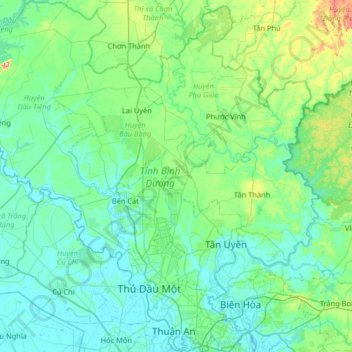
Name: Bình Dương Province topographic map, elevation, terrain.
Location: Bình Dương Province, Vietnam (10.86346 106.32789 11.50159 106.96669)
Average elevation: 38 m
Minimum elevation: -2 m
Maximum elevation: 265 m
Bình Dương province is situated on relatively level terrain, and is crossed by the Saigon, Đồng Nai, and Bé rivers. It also has some hills. Bình Dương can be seen from the Lái Thiêu central church. Although Bình Dương is flat, it is higher than Ho Chi Minh City. Across Bình Dương there are many different topographic regions, including low mountainous terrain with slight undulation, flat plains and alluvial valleys. There are some low mountains, including Châu Thới in Dĩ An and Cậu mountain (also called Lấp Vò) in Dầu Tiếng district and some low hills. Natural effects have created many different types of landform including worn areas, accumulative areas (due to the deposition of corrosive materials in the flow) and some areas that are worn, accumulative and depositional at the same time. This is due to rainfall and the flow affecting the ground, with the effects of wind, temperature, climate, the erosion and collapse due to gravity of the geology. The impact took place over millions of years.
Other topographic maps
Click on a map to view its topography, its elevation and its terrain.
Scenic Viewpoint
Vietnam > Ninh Bình Province > Hoa Lư District > Tam Cốc
Scenic Viewpoint, Thai Vi, Tam Cốc, Hoa Lư District, Ninh Bình Province, 08213, Vietnam
Average elevation: 27 m
Fansipan
Vietnam > Lao Cai province > Sa Pa > Hoang Lien Commune
Fansipan, Hoang Lien Commune, Sa Pa, Lào Cai Province, Vietnam
Average elevation: 2,616 m
Hàm Thuận Nam District
Hàm Thuận Nam District, Binh Thuan province, Vietnam
Average elevation: 124 m
Van Giang District
Vietnam > Hung Yen Province > Van Giang District
Van Giang District, Hung Yen Province, 163906, Vietnam
Average elevation: 6 m
Ngoc Hien District
Ngoc Hien District, Ca Mau province, Vietnam
Average elevation: 1 m
Bien Hoa
Vietnam > Dong Nai province > Bien Hoa
Bien Hoa, Bien Hoa City, Dong Nai province, 81000, Vietnam
Average elevation: 24 m
Kiến Giang
Vietnam > Quang Binh province > Kiến Giang
Kiến Giang, Lệ Thủy District, Quang Binh province, Vietnam
Average elevation: 3 m
Sa Pa District
Sa Pa District, Lao Cai province, Vietnam
Average elevation: 1,276 m
Ho Chi Minh City
Vietnam > Ho Chi Minh City > Ho Chi Minh City
Ho Chi Minh City, District 1, Ho Chi Minh City, 00084, Vietnam
Average elevation: 6 m
Tây Ninh
Vietnam > Tay Ninh province > Tây Ninh
Tây Ninh, Tây Ninh City, Tay Ninh province, 0276, Vietnam
Average elevation: 17 m
Binh Duong Province
Binh Duong Province, Vietnam
Average elevation: 121 m
Hoàng Mai
Hoàng Mai, Nghe An province, 465240, Vietnam
Average elevation: 45 m
Vạn Ninh District
Vạn Ninh District, Khanh Hoa province, Vietnam
Average elevation: 316 m
Tam Đường District
Tam Đường District, Lai Chau province, Vietnam
Average elevation: 1,312 m