
Thank you for supporting this site ❤️
Make a donation
Make a donation
Brower Hill topographic map
Click on the map to display elevation.
Thank you for supporting this site ❤️
Make a donation
Make a donation
About this map
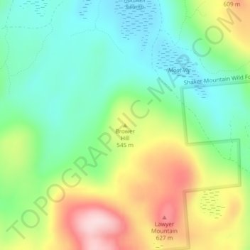
Name: Brower Hill topographic map, elevation, terrain.
Average elevation: 488 m
Minimum elevation: 388 m
Maximum elevation: 660 m
Thank you for supporting this site ❤️
Make a donation
Make a donation
Other topographic maps
Click on a map to view its topography, its elevation and its terrain.
Thank you for supporting this site ❤️
Make a donation
Make a donation
City of Gloversville
United States > New York > Fulton County
The city sits in the foothills of the Adirondack Mountains and therefore is within a climatic transition zone. Gloversville experiences the warmer summer temperatures common throughout the Capital Region, Hudson Valley, and Mohawk Valley while experiencing generally more copious precipitation throughout the…
Average elevation: 262 m
Thank you for supporting this site ❤️
Make a donation
Make a donation
Thank you for supporting this site ❤️
Make a donation
Make a donation