
Make a donation
Pembroke topographic map
Click on the map to display elevation.
Make a donation
About this map
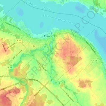
Name: Pembroke topographic map, elevation, terrain.
Location: Pembroke, Eastern Ontario, Ontario, Canada (45.78447 -77.15977 45.84756 -77.07323)
Average elevation: 128 m
Minimum elevation: 106 m
Maximum elevation: 160 m
Make a donation
Other topographic maps
Click on a map to view its topography, its elevation and its terrain.
Upsala
Canada > Ontario > Thunder Bay District > Unorganized Thunder Bay District
Average elevation: 487 m
Yellowhead Island
Canada > Ontario > Muskoka District > Georgian Bay Township
Average elevation: 182 m
Make a donation
Papineau Lake;Wapoose Creek
Canada > Ontario > Thunder Bay District > Greenstone
Average elevation: 347 m
Make a donation
Avonmore
Canada > Ontario > Stormont, Dundas and Glengarry Counties > North Stormont
Average elevation: 95 m
Make a donation
London
London has a humid continental climate (Köppen Dfb), though due to its downwind location relative to Lake Huron and elevation changes across the city, it is virtually on the Dfa/Dfb (hot summer) boundary favouring the former climate zone to the southwest of the confluence of the South and North Thames Rivers,…
Average elevation: 269 m
Make a donation
Tipperary Island
Canada > Ontario > Leeds and Grenville Counties > Leeds and the Thousand Islands
Average elevation: 103 m
Make a donation
Make a donation
Potato Island
Canada > Ontario > Kenora District > Unorganized Kenora District
Average elevation: 347 m
Make a donation