
Make a donation
Villeta topographic map
Click on the map to display elevation.
Make a donation
Villeta
Villeta is a municipality and town in Cundinamarca (Colombia), located in Gualivá Province, approximately 84 kilometres (52 mi) northwest of Bogota, considered the capital of the province. Its name means "Little Village". The municipality borders Quebradanegra and Nimaima in the north, Nocaima and Sasaima in the east, Albán and Vianí in the south and Guaduas in the west. It is situated at an altitude of 850 metres (2,790 ft) in the Eastern Ranges of the Colombian Andes
Make a donation
About this map
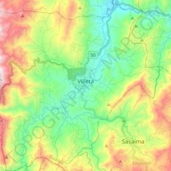
Name: Villeta topographic map, elevation, terrain.
Location: Villeta, Gualivá, Cundinamarca, Colombia (4.94145 -74.54388 5.07422 -74.41233)
Average elevation: 1,144 m
Minimum elevation: 687 m
Maximum elevation: 1,945 m
Make a donation
Other topographic maps
Click on a map to view its topography, its elevation and its terrain.
Medellín
Colombia > Antioquia > Medellín
Medellín has 16 comunas (districts), 5 corregimientos (townships), and 271 barrios (neighborhoods). The metropolitan area of Medellín lies within the Aburrá valley at an elevation of 1,500 metres (4,900 feet) above sea level and is bisected by the Medellín River (also called Porce), which flows northward.…
Average elevation: 2,098 m
Make a donation
Reserva Natural de la Sociedad Civil El Palmichal
Average elevation: 2,576 m
Make a donation
Make a donation
Make a donation
Make a donation
Make a donation
Make a donation
Sincelejo
The geography of Sincelejo is characterized by a hilly landscape which extends from the mountains to the borders of the plateau in the north and south. The small mountain foothills in the municipality span from the marine fluvial plain in the west to the border shared with the town of Palmito. Erosion is…
Average elevation: 121 m
Make a donation
Sogamoso
Sogamoso (Spanish pronunciation: [soɣaˈmoso]) is a city in the department of Boyacá of Colombia. It is the capital of the Sugamuxi Province, named after the original Sugamuxi. Sogamoso is nicknamed "City of the Sun", based on the original Muisca tradition of pilgrimage and adoring their Sun god Sué at the…
Average elevation: 2,901 m
Make a donation
Make a donation
Make a donation
Make a donation
Make a donation
Make a donation
Make a donation
Altamira
Altamira is a small pueblo in the department Huila, with a population around 2,416. Its geographical coordinates are 2° 3' 46" North, 75° 47' 14" West. It is about an 8-hour bus trip south of Bogota. The largest city in Huila and its capital is Neiva, which is 89 miles north, with a population of about…
Average elevation: 1,032 m
Make a donation
Cordillera Oriental
The Cordillera Oriental montane forests ecoregion covers the eastern slopes of the cordillera and its northern end. The Magdalena Valley montane forests cover the western slopes. The Northern Andean páramo covers the highest elevations.
Average elevation: 4,825 m
Make a donation
Make a donation
Make a donation
Make a donation
Make a donation
Make a donation
Make a donation
Make a donation
Make a donation