
Martinique topographic map
Interactive map
Click on the map to display elevation.
About this map
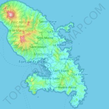
Name: Martinique topographic map, elevation, terrain.
Location: Martinique, Frankreich (14.38867 -61.22903 14.87873 -60.80970)
Average elevation: 67 m
Minimum elevation: -1 m
Maximum elevation: 1,370 m
Die Insel hat eine Länge von 73 km und eine Breite von 39 km. Die Küstenlinie ist rund 350 km lang. Die Insel ist bergig. Im Norden der Insel liegt der Vulkan Montagne Pelée, der eine Höhe von 1.397 m hat.
Other topographic maps
Click on a map to view its topography, its elevation and its terrain.
Grand'Rivière
Frankreich > Martinique > Grand'Rivière
Grand'Rivière, La Trinité, Martinique, 97218, Frankreich
Average elevation: 368 m
Le Vauclin
Frankreich > Martinique > Le Vauclin
Le Vauclin, Le Marin, Martinique, 97280, Frankreich
Average elevation: 40 m