Hudson River topographic map
Click on the map to display elevation.
Hudson River
The Hudson then flows south, taking in Beaver Brook and the outlet of Lake Harris. After its confluence with the Indian River, the Hudson forms the boundary between Essex and Hamilton counties. In the hamlet of North River, the Hudson flows entirely in Warren County and takes in the Schroon River. Further south, the river forms the boundary between Warren and Saratoga Counties. The river then takes in the Sacandaga River from the Great Sacandaga Lake. Shortly thereafter, the river leaves the Adirondack Park, flows under Interstate 87, and through Glens Falls, just south of Lake George although receiving no streamflow from the lake. It next goes through Hudson Falls. At this point the river forms the boundary between Washington and Saratoga Counties. Here the river has an elevation of 200 feet (61 m). Just south in Fort Edward, the river reaches its confluence with the Champlain Canal, which historically provided boat traffic between New York City and Montreal and the rest of Eastern Canada via the Hudson, Lake Champlain and the Saint Lawrence Seaway. Further south the Hudson takes in water from the Batten Kill River and Fish Creek near Schuylerville. The river then forms the boundary between Saratoga and Rensselaer counties. The river then enters the heart of the Capital District. It takes in water from the Hoosic River, which extends into Massachusetts. Shortly thereafter the river has its confluence with the Mohawk River, the largest tributary of the Hudson River, in Waterford. The river then reaches the Federal Dam in Troy, marking an impoundment of the river. At an elevation of 2 feet (0.61 m), the bottom of the dam marks the beginning of the tidal influence in the Hudson as well as the beginning of the lower Hudson River.
About this map
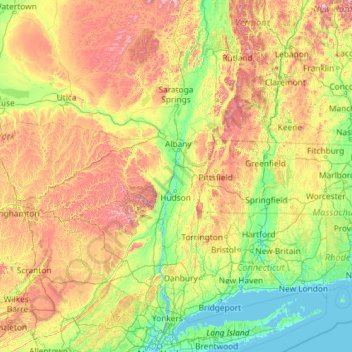
Name: Hudson River topographic map, elevation, terrain.
Location: Hudson River, New York, United States (40.65258 -74.19885 44.09099 -73.57319)
Average elevation: 297 m
Minimum elevation: -2 m
Maximum elevation: 1,384 m
Other topographic maps
Click on a map to view its topography, its elevation and its terrain.
Central Park
United States > New York > New York County > New York
In June 1856, Fernando Wood appointed a "consulting board" of seven people, headed by author Washington Irving, to inspire public confidence in the proposed development. Wood hired military engineer Egbert Ludovicus Viele as the park's chief engineer, tasking him with a topographical survey of the site. The…
Average elevation: 26 m

Tug Hill
United States > New York > Oswego County
The core Tug Hill region encompasses 150,000 acres (610 km2) of unbroken, generally second-growth, northern hardwood forest, and is drained by a vast network of streams. Important rivers and streams whose headwaters are located within the Tug Hill region include the Mohawk River, Deer River, Salmon River, Mad…
Average elevation: 109 m
South New Berlin
United States > New York > Chenango County > Town of New Berlin
Average elevation: 380 m
Shinnecock Indian Territory
United States > New York > Suffolk County > Town of Southampton
Average elevation: 4 m

Grace and Messena Park
United States > New York > Onondaga County > City of Syracuse
Average elevation: 134 m


Valley Pond Estates
United States > New York > Westchester County > Town of Somers > Lincolndale
Average elevation: 128 m
Central Park
United States > New York > New York County > New York
In June 1856, Fernando Wood appointed a "consulting board" of seven people, headed by author Washington Irving, to inspire public confidence in the proposed development. Wood hired military engineer Egbert Ludovicus Viele as the park's chief engineer, tasking him with a topographical survey of the site. The…
Average elevation: 26 m


East Poestenkill
United States > New York > Rensselaer County > Town of Poestenkill
Average elevation: 376 m
Purdys Grove
United States > New York > Westchester County > Village of Port Chester
Average elevation: 14 m


Jayne's Hill
United States > New York > Suffolk County > Town of Huntington
Jayne's Hill (also known as High Hill, West Hills, Oakley's Hill, and Janes Hill) is the highest point on Long Island, New York, with an elevation of between 387 feet (118 m) and 400.9 feet (122.2 m) above sea level. It is situated on the Harbor Hill moraine, a terminal moraine that makes up the northern spine…
Average elevation: 73 m



Ellenburg Mountain
United States > New York > Clinton County > Town of Ellenburg
Average elevation: 682 m
Preston Hollow
United States > New York > Albany County > Town of Rensselaerville
Average elevation: 372 m


Whitesville
United States > New York > Allegany County > Town of Independence
Average elevation: 611 m
Potter Hollow
United States > New York > Albany County > Town of Rensselaerville
Average elevation: 346 m
Hartmans Corners
United States > New York > Albany County > Town of Guilderland
Average elevation: 81 m

Pleasantside
United States > New York > Westchester County > Town of Cortlandt
Average elevation: 108 m
West Coxsackie
United States > New York > Greene County > Village of Coxsackie
Average elevation: 33 m

Brick House Corners
United States > New York > Genesee County > Town of Pembroke
Average elevation: 262 m
West Frankfort
United States > New York > Herkimer County > Town of Frankfort
Average elevation: 144 m
Mariandale
United States > New York > Westchester County > Village of Ossining
Average elevation: 53 m

Middle Granville
United States > New York > Washington County > Town of Granville
Average elevation: 156 m


Inwood Hill Park
United States > New York > New York County > New York
Inwood Hill Park is a 196 acres (79 ha) public park in the Inwood neighborhood of Manhattan, New York City, operated by the New York City Department of Parks and Recreation. On a high schist ridge that rises 200 feet (61 m) above the Hudson River from Dyckman Street to the northern tip of the island, Inwood…
Average elevation: 14 m

Brooklyn Bridge Park
United States > New York > Kings County > New York
Brooklyn Bridge Park spans 85 acres (34 ha) of the East River waterfront in the Brooklyn Heights and Dumbo neighborhoods of Brooklyn. The park is divided into eleven sections: Piers 1 through 6; Fulton Ferry Landing; Brooklyn Bridge Plaza; Empire Fulton Ferry; Main Street; and John Street. Each of these…
Average elevation: 9 m

Sonyea State Forest
United States > New York > Livingston County > Town of Mount Morris
Average elevation: 231 m